From the Archives, August 14, 2016

Rock Island Leader’s Guide

Most everyone knows that the Council puts out a Leaders’ Guide every year to let Scoutmasters know what Boxwell will offer in the coming summer.  Currently, the guide is a CD and online; in 1955, it was still very much a print edition!

There are several things about the Leaders’ Guide for Rock Island Boxwell that are interesting, but for right now, let’s focus on page 10.  This lays out the Camp Schedule for the summer of 1955.

The first thing you’ll notice is that camp runs for 8 weeks.  Add Staff Week onto the front end and you have 9 weeks of camp.

The next thing you might notice is that each week is broken down by district.  In other words, every district had assigned weeks for their troops to come to camp.

Finally, you’ll notice the cost.  That’s right, in 1955 it cost less than $20 a week to attend Boxwell!

Rock Island Leaders' Guide

A page from the 1955 Leaders’ Guide for Rock Island Boxwell.

From the News, August 10, 2016

We thought we’d continue the inauguration of our new series with another article on Boxwell dedications.  This time we jump forward a few years to 1995 and the capstone of the 1994 Capital Development Campaign: CubWorld.  We have more interesting information on CubWorld coming in the near future, but for now, here is the Tennessean story covering the event from the end of October, 1995.

CubWorld Dedication

“Young Scouts Give Merit to Cubworld,” _The Tennessean_, October 27, 1995, pg. 93

From the Archives, August 7, 2106

Camp Craig Road Sign Mystery

As we pointed out a few weeks ago with our original Boxwell Development maps, there are several “might have beens” in Boxwell history.  The same holds true not just in 1960, but later with the 1972 Capital Development Campaign.  If you recall, this was the campaign that built Camp Craig.

Take a good look at the image here.  This is a Boxwell sign pointing to Camp Craig, Stanford Chapel, and Explorer Island.  Given the curve and the dirt road, this is the sign at the branch that today leads to the pool, the shotgun range, and COPE.  But take a good look at the sign and you’ll see that the arrows point to the right for Craig and the chapel, not to the left!

In its early days, Camp Light was truly a wilderness camp.  Aside from the road that runs to Duck Head and Explorer Island and the Chapel itself, there was NOTHING in Camp Light.  The 1972 Campaign changed all that.  A new road was cut through Camp Light and this was going to be the road to Craig.  Indeed, this is where Craig’s electric and water lines are run.  It was also during this campaign that loops were cut into Camp Light; there was even an area cut out for dining hall for potentially a FIFTH camp!  Akers’ idea was that there would be Murrey, Stahlman, Parnell, Craig, Unknown Camp, and then Light, which would cover all the area between this fire road (the one that ends at Site 16 at Craig) and today’s Fehrmann Training Center.

So, what happened?  As with all Capital Development Campaigns, not all the money that was pledged came in as expected.  Further, as is also the case with capital development, projects started coming in more expensive than originally anticipated.  Thus, as the money was drying up, Craig only got the one permanent showerhouse and it was deemed simpler to keep the existing road and just make new signs!

Craig Road sign

The original Craig road sign as it appeared in 1974. Note that the arrows point right, not left!

From the News, August 3, 2016

If you’re going to start a new series, you need to get things started with a bang!  So, we’re going to inaugurate this news series with an article from Tennessean, specifically from July 10, 1960.  What’s so special about this date?  It was the day the official dedication ceremonies were held at the “new” Boxwell at Old Hickory Lake.

Dedication

_The Tennessean_, Sunday, July 10, 1960, pg. 71

Website Updates

For the most part, we’ve been fairly quiet over here at VirtualBoxwell.org.  A few weekly postings, but nothing BIG.  Well, that’s because we’ve been busy!  So, as summer camp is now over, we can finally reveal what we’ve been working on.

There are several updates to the site, some large and some small.  There are two “big” changes, so we’ll touch on those first.

The “biggest” change (and we mean “big” because of the amount of work involved) is a total overhaul of the camp maps section (http://www.virtualboxwell.org/camp.php). Every map has been rebuilt from the ground up, each created from actual maps of Boxwell.  Thus, for the first time, the maps are actually shaped and proportioned to reflect the way Boxwell is actually laid out!  No more hand-drawn maps; these are the real deal.  New icons have been added and all new photos have been taken.  In short, just about every aspect of the camp maps has been redesigned and rebuilt to present Scouts and Scouters with a better layout of their camp.

The second “big” change will start on Wednesday.  We will be adding a new section to our blog and Facebook feed: From the News.  From the News will be articles from local newspapers (mostly the Tennessean and the Nashville Banner) about Boxwell and the Council.  In short, we will be providing “first draft” history of Middle Tennessee Council and Boxwell as it was being written.  It should be an interesting look at how things were “back in the day”!

As for the smaller changes…

We’ve updated the Staff Photos page.  We have new staff photos for Craig, Stahlman, CubWorld and the Reservation staffs.  Check this out at http://www.virtualboxwell.org/staff.php.

As we do every three months or so, we’ve updated the banner image.  The new banner is a photo taken by Michael Seay in 1978… from the air!  The original photo is below.

We’ve also updated the “About Us” section (http://www.virtualboxwell.org/about.php), conducted several interviews with past staff members (Ron Turpin, Larry Green, and Christy Willhite Bryant last summer and Jim Barr and the daughters of Ed Human this summer), updated the “Master List” for future reunions with almost 200 additions and corrections, and tried to track down an old time capsule.  It has been a busy summer!

We’d like to give a special thank you to a number of people who have helped make all of this possible.  To Russell Parham and Cameron Grady, who took photos for the new maps.  To Michael Seay, Eric Cole, and Chris Eckert, whose historic photos of Boxwell continue to find their way into “classic Parnell.” To JJ Norman, Noah Davis, Meredith MaGuirk, Jason Flannery, and John Kasper, whose contributions of staff photos in recent years keeps us current!

We’re still working on a variety of other long term projects.  Keep checking in to see what surprises await!

Craig Banner

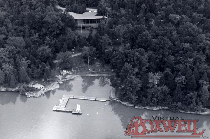
Craig Dining Hall and original waterfront from the air, July 14, 1978. Photo by Michael Seay